Day 5: Introduction to Corrections
Lecturer: Dr. Andrew, Senior Researcher, Navigation Systems Laboratory
Date: March 2003
Andrew Walks Through the Research Institute
Andrew was walking down the corridor of the research institute, carrying a thick folder of formulas under his arm. It was not his first year on the job, but every time he had to explain the principles of GPS and the importance of corrections, he felt a certain excitement. Andrew was a middle-aged senior researcher specializing in navigation systems. He loved his work and knew how difficult it could be for people "off the street" to understand why GPS is not as simple as it seems.
Today he would be giving a new lesson to a group of students. They were young people: some were already familiar with the basics of radio engineering, some had only seen GPS on a smartphone, and all were curious, albeit slightly wary. Andrew's reputation as a tireless theorist preceded him.
The Lecture Hall and First Impressions
The lecture hall Andrew entered was quite spacious. Future engineers and graduate students were seated in rows. On the board were fragments of formulas labeled with Latin and Greek symbols. On the wall hung posters showing satellite diagrams, orbits, and charts of signal delays.
When Andrew took his place at the lectern, he glanced around the audience and began unhurriedly: "Good day. If you haven't managed to review the previous material, don't worry. Today we'll talk about how GPS 'sees' the world and why this system vitally needs various corrections."
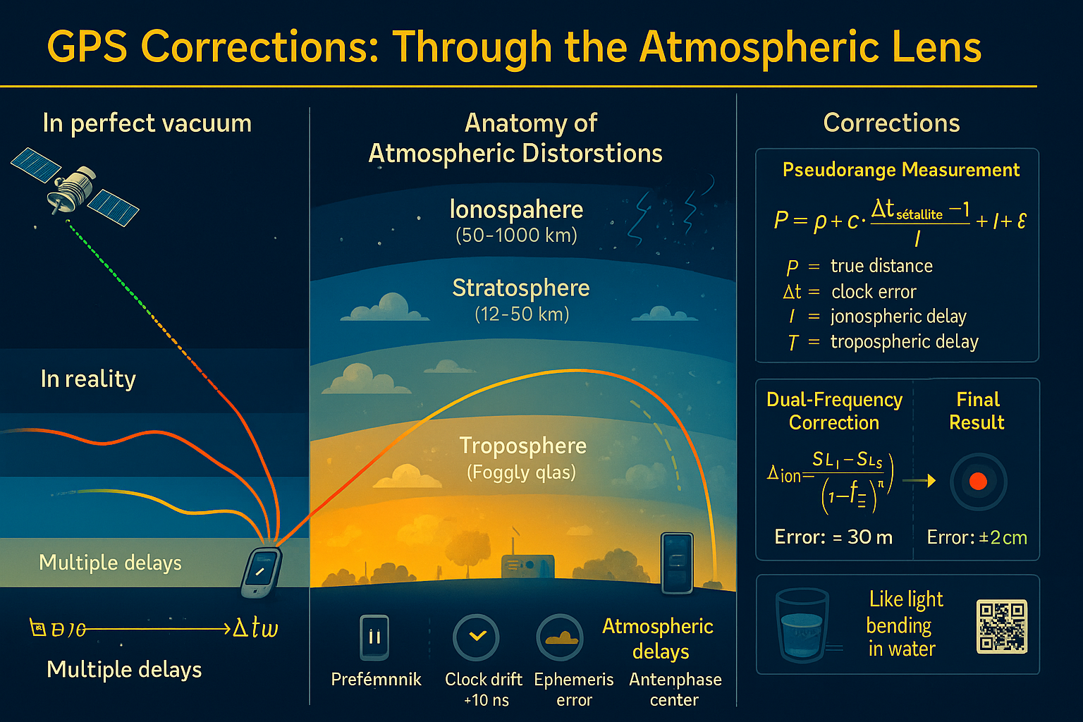
Some of the listeners took out notebooks, while others opened their laptops. Andrew paused briefly, trying to set a serious tone: "I'm sure many of you think that GPS is simply satellites telling us our coordinates. In reality, it goes much deeper. Satellites do indeed transmit signals, and by knowing the speed of light, we can calculate the distance to them. But here's the problem: the signal doesn't travel through a perfect vacuum. Our atmosphere (the troposphere and the ionosphere) introduces interference, and we must account for these distortions to avoid errors that sometimes reach tens of meters."
A Simple Analogy and the First Formulas
To warm up the audience, Andrew pulled a small rubber ball out of his pocket: "Imagine this ball is a satellite," he said, placing it at one end of the table. "And over here, at the other end, is my phone—this is the GPS receiver. The satellite sends a signal with a timestamp. The receiver measures how long it took for the signal to arrive, multiplies that time by the speed of light, and gets the distance."
Andrew picked up an empty glass: "Imagine this glass as an ideal space without atmosphere. The beam passes through it without refraction. But now..." — he filled the glass with water — "...this is the troposphere and ionosphere. If we send light through water, it bends, changing its speed. The same thing happens with the GPS signal."
He took a laser pointer and aimed it through the water, demonstrating how the beam deflects. "Just like water in the glass bends the light, the atmosphere slows down and distorts the radio signal. The lower the satellite is on the horizon, the longer the signal path and the greater the error. And if we add the ionosphere on top, charged particles affect the radio wave in a different way."
Andrew narrowed his eyes, as if recalling one of his first field experiments: "And to compensate for all these effects, there are special models and formulas. Let's take a look at the most basic ones."
He turned to the board, where a few key equations had been written in advance. First, he pointed to the 'pseudorange' equation:
"Here:
- \(\rho\) is the actual distance to the satellite
- \(c\) is the speed of light
- \(\Delta t\) is the difference between the satellite's and the receiver's clock readings (remember, satellites have atomic clocks, but your phone unfortunately does not)
- \(I\) is the ionospheric delay
- \(T\) is the tropospheric delay
- \(\epsilon\) represents various noise
The pseudorange is not the perfect distance; it's a value that contains errors."
Troposphere: "Fogged Glass"
Andrew took a poster from a stack and pinned it up next to the board: "The troposphere is the lower layer of the atmosphere; it depends on pressure, temperature, and humidity. It distorts our signal like a fogged-up piece of glass through which we try to see something. To correct for the troposphere's effects, we introduce special corrections:
Andrew explained, pointing to the formula. "Here, \(\Delta_c^j\) is the 'dry' component, which can be calculated based on temperature and pressure, while \(\Delta_{wet}^j\) is the 'wet' component, which depends on water vapor. The dry part is more predictable, but the wet part changes constantly."
He showed the audience a printout with even more complex formulas: "In these formulas, you'll see coefficients \(a\), \(b\), \(c\), as well as parameters \(\delta P\), \(\delta t\), \(\delta \beta\), \(\delta H_T\). All of these are needed to account for real atmospheric conditions at the moment the signal is received."
Ionosphere: "Scratches on the Glass"
Switching his attention to the next poster, Andrew continued: "The ionosphere is the upper layer of the atmosphere, filled with charged particles. It delays radio waves especially strongly when the Sun is active," he said, tapping a bright diagram of solar wind interacting with Earth's magnetosphere. "In regions closer to the equator or the poles, the effect is even stronger."
He emphasized that GPS typically uses multiple frequencies—L1 and L2: "Signals on different frequencies slow down in different ways. So by comparing how these frequencies arrive, we can calculate the ionospheric correction:
"In essence, by measuring the difference in propagation speed of signals at frequencies \(f_{L1}\) and \(f_{L2}\), we determine the degree of delay in the ionosphere and correct the coordinates."
Applying Corrections and Final Accuracy
Having finished the explanation, Andrew drew a line on the board and wrote:
"These formulas show how tropospheric and ionospheric corrections are added to the original data. Without taking all these terms into account, GPS errors can reach tens of meters. But if we apply the corrections, we can achieve accuracy down to a few centimeters—it all depends on the equipment and models used."
Real-World Problems: Multipath and Synchronization
Andrew walked along the board, pointing to a list of typical interferences:
- Multipath propagation: The signal bounces off buildings, mountains, trees. The receiver can be confused by receiving reflected signals. To avoid this, directional antennas and advanced algorithms are used to filter out unwanted signals.
- Receiver clock error: Satellites have atomic clocks, while receivers do not. Therefore, the system continuously "checks" with multiple satellites to calibrate its timing.
- Ephemeris error: Incorrect knowledge of the satellites' own coordinates leads to additional inaccuracies. Ground stations help by periodically updating data on each satellite's precise position.
"We also strive to remove or minimize all these factors," Andrew noted. "In the end, we get a working system where the error can become very small, provided we correctly account for everything that happens to the signal."
A Visual Demonstration
One of the graduate students asked, "Andrew, can you explain in simpler terms why we need all these models, since GPS seems to work fine anyway?"
Hearing this, Andrew smiled. He picked up the rubber ball again: "Imagine you're trying to see a distant mountain through a fogged window. The troposphere is the fogging that slightly blurs the picture. The ionosphere is scratches and interference on the glass surface. Without corrections, your 'view' would be inaccurate. But by cleaning the glass and putting on the right glasses (i.e., applying corrections), you get a clear picture. The same goes for the GPS signal."
Final Thoughts
Andrew looked around the audience. The young scientists listened intently; some were taking notes, others were examining the formulas with newfound interest, no longer intimidated by their appearance.
"So, we've covered everything from the basic principles—how pseudorange is measured and why it's not perfect—to the specific formulas that help compensate for tropospheric and ionospheric delays. We've seen how multipath propagation and clock errors influence the result, and learned that GPS is not just an icon on your phone but a vast network of technologies, models, and correction stations. In the end, we get coordinates with impressive accuracy."
He set aside his papers and addressed the group: "Remember, satellites are thousands of kilometers away. We receive their signals in real time, and even the slightest inaccuracy in time measurement or any atmospheric delay can distort the result. Yet, thanks to a complex system of corrections and the work of many people, GPS is so precise that it helps us everywhere—from everyday navigation to geodesy and cartography with centimeter-level accuracy."
The lecture ended. The graduate students began animatedly discussing what they had heard, asking questions, and debating the nuances of the calculations. Andrew left the lecture hall feeling satisfied: once again, he had shown the depth and beauty of the technology we so often take for granted. And perhaps, that day marked the start of someone's journey toward new discoveries in the world of high-precision navigation.